
Compassion That Reaches the Arabian Shore
30 June 2026
Nadia Nur Imani is determined to fulfill her mother's dream by becoming a nurse, opening a new path to The Land of the Two Holy Mosques


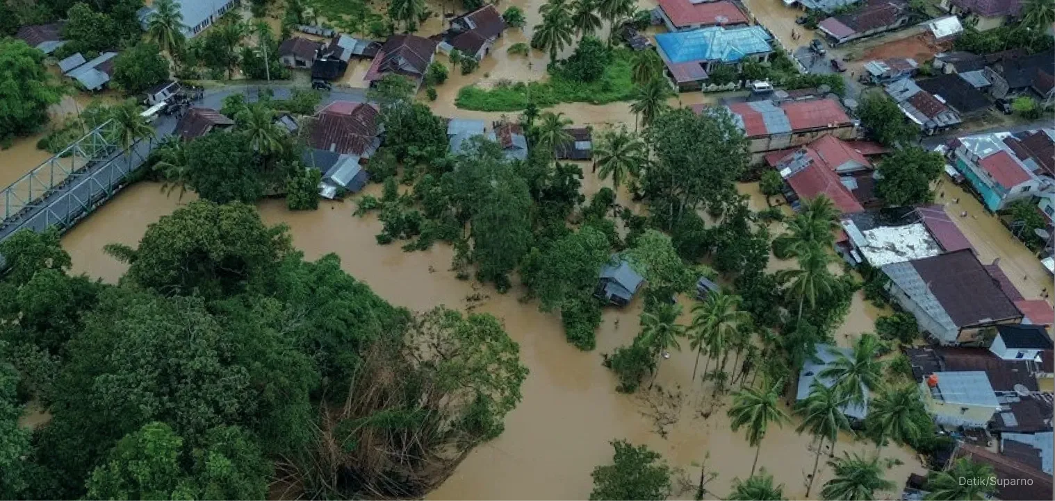
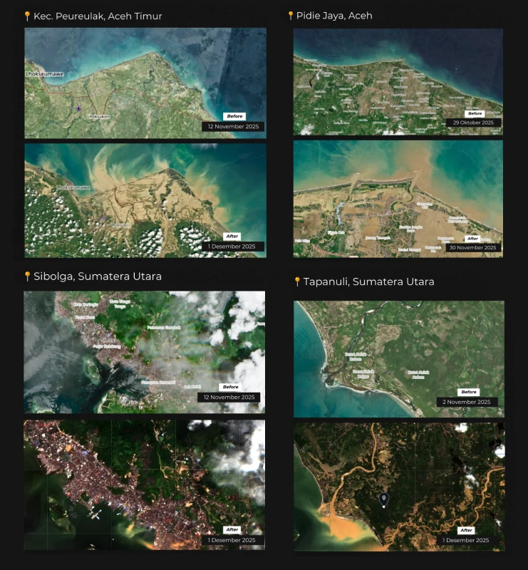
The end of November 2025 became a dark chapter for the people of Aceh, North Sumatera, and West Sumatera. Days of uninterrupted heavy rain turned normally calm rivers into violent currents that devastated residential areas.
The flash floods and landslides submerged villages, destroyed public facilities, and cut off access to electricity, roads, and communication. The situation continued to worsen day by day.
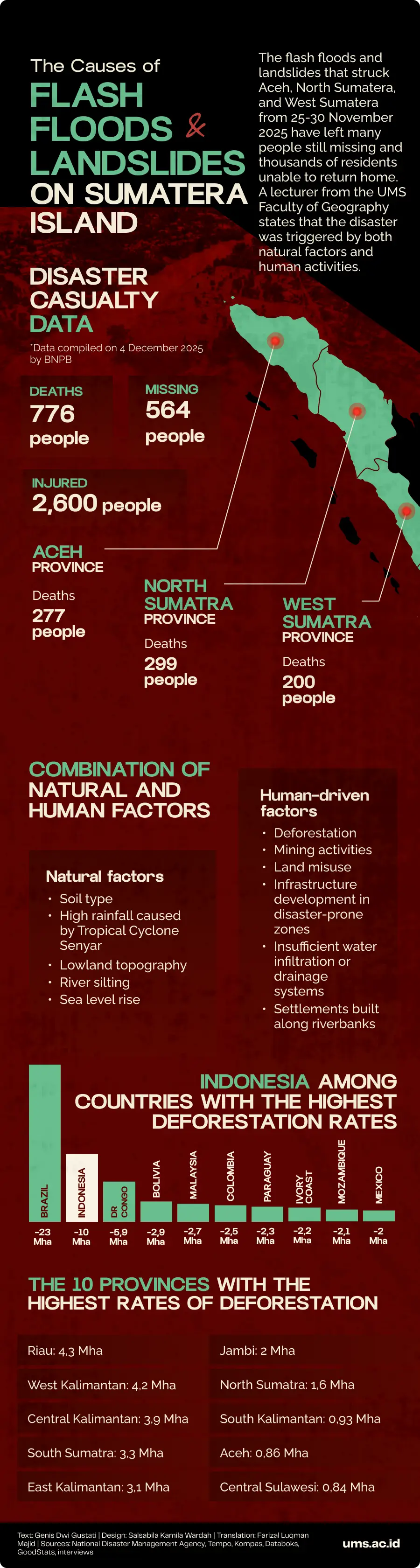
The National Disaster Management Agency (BNPB) dashboard recorded a continuing rise in casualties. As of 4 December 2025 at 13.05 WIB, the number of validated fatalities had reached 776 people, with 564 reported missing, and 2.6 thousand injured.
Tempo reported that many affected areas could only be reached two to three days after the incident, as road access was buried under landslides. Thousands of displaced residents are now living in emergency tents, relying on food, clean water, and medicine supplies.
Why was the disaster that struck Sumatera so massive? What caused it? According to Dr. Annisa Trisnia Sasmi, S.Si., M.T., a lecturer at the Faculty of Geography, Universitas Muhammadiyah Surakarta (UMS), the answer cannot be reduced to a single cause.
Annisa explained that this event is a clear example of how hazards, vulnerability, and response capacity intersect. “A flood disaster of this scale almost never stands alone. The causes involve both natural factors and human intervention,” she said, Thursday (4/12/2025).
The lecturer of the course Disaster Management in Tropical Regions began with the natural factors that triggered the initial event. The rainfall was far beyond normal levels.
Meteorological data showed that rainfall across Sumatera reached more than 300 millimeters per day, an extreme figure for a tropical region. This condition was intensified by the presence of Tropical Cyclone Senyar (previously detected as storm seed 95B) in the Malacca Strait, which drew in large amounts of moisture and concentrated precipitation over Aceh, West Sumatera, and North Sumatera.
“The cyclone drew in clouds from the ocean, causing the rainfall to last much longer and become more intense. In hydrometeorology, this is what we refer to as a hazard” Annisa explained.
However, extreme rainfall was not the only contributing factor. The region’s topography also played a significant role. Most of the affected areas sit on lowlands and the downstream parts of the watershed (DAS), locations that naturally become collection points for water flowing from higher elevations.
“In the floods that hit North Sumatera, West Sumatera, and Aceh, most of the impacted areas were located far from mountainous regions,” she added.
This process was further exacerbated by soil conditions. Annisa noted that in several locations, the soil type is dominated by clay-rich material, which absorbs water poorly.
“When rainfall continues for an extended period, the soil becomes saturated and the water shifts into surface runoff. Under ideal conditions, most rainwater would infiltrate the soil, with the rest carried away by rivers,” Annisa said. However, when the soil can no longer absorb water and rivers lose their capacity to contain it, flooding becomes inevitable.
River sedimentation further worsened the situation. Sediment carried from upstream areas, household waste, and alterations to the river’s natural course all contributed to water discharge rising faster than the river could handle.
Large-scale deforestation, exacerbated by the expansion of oil palm plantations, mining activities, housing developments along riverbanks, and infrastructure construction in landslide-prone zones, has also stripped forests of their function as natural water buffers and soil stabilizers. This combination of land-use changes not only triggered the disaster but allowed it to spread and intensify its impacts.
“The triggers of a disaster must also be seen from the extent to which humans have altered the natural landscape. When vegetation disappears, water no longer infiltrates the soil, it flows directly as surface runoff in large volumes and can turn into a flash flood,” she explained.
Deforestation in conservation areas and hill regions along the Bukit Barisan range has stripped forests of their function as natural sponges. Annisa expressed concern over the drastic changes occurring in upstream river areas that should serve as Water Catchment Areas (DTA).
More specifically, Annisa pointed out several forms of land-use conversion in upstream zones that weaken the hydrological system, such as the construction of the Batang Toru hydropower plant (PLTA) in South Tapanuli, which alters the landscape structure and affects slope stability; the massive expansion of oil palm plantations in the Leuser Ecosystem Area in Aceh; and illegal logging in the Bukit Barisan region of West Sumatera.
“All of these projects and activities were also presented in my class yesterday as a shared reflection for students. Natural hazards will always exist, but the risks escalate when humans occupy places they shouldn’t, and that creates consequences,” she reminded.
For disaster experts, the period after the water recedes is often the most critical stage. According to Annisa, initial responses such as evacuation, logistics, and medical treatment have been appropriate.
Next, recovery efforts must begin in the upstream areas of the watershed, where ecological functions were first disrupted. Rehabilitation of upstream regions including reforestation of damaged areas, restoration of green belts, and protection of protected forests and conservation zones, forms the foundation for restoring the land’s ability to absorb water.
The government is advised to review land-use permits, especially those in river corridors and on landslide-prone slopes. Rivers must be restored to their proper function, water infiltration zones or drainage areas created, and all infrastructure development must follow disaster-risk maps.
Disaster mitigation also means building an early warning system connected directly to grassroots communities. “Disaster education or drills in schools and disaster-prone villages need to become part of risk management,” said Annisa.
Relocation becomes the last option for settlements built directly along flood paths or landslide tracks. “Relocation is often rejected because it is seen as taking away people’s livelihoods. But in urgent post-disaster conditions, relocation becomes the right decision to survive and thrive,” she explained.
In a separate interview, UMS disaster expert Prof. Dr. Kuswaji Dwi Priyono, M.Si., expressed regret over the government’s slow response in elevating the disaster status to a national disaster. The designation of a national disaster is not determined solely by the number of victims or the scale of destruction, but by the regional government’s capacity to handle the disaster’s impact administratively, financially, and operationally.
The regulations forming the legal basis include Law No. 24 of 2007 on Disaster Management and Government Regulation No. 21 of 2008 on the Implementation of Disaster Management, which classify disaster status according to authority: local, provincial, and national.
Indonesia, Kuswaji stressed, does not recognize the term regional disaster, a phrase often used by the public or media. If the impact extends beyond the boundaries of a district, the status may be elevated to provincial. However, if the impact crosses provincial borders, overwhelms regional capacity, or requires the deployment of national resources, including the military and police, central government intervention, or international assistance, then the president may declare it a national disaster.
Dating back, Kuswaji referred to the 2004 Aceh-North Sumatra tsunami. That event was never labeled a regional disaster; it was immediately categorized as a national disaster because it fulfilled all the indicators.
“The post-disaster management also involved large-scale international assistance, an indicator that reinforces its status as a national disaster,” explained the central board member of the Indonesian Disaster Experts Association, Thursday (4/12/2025) in an online interview.
The flash floods and landslides that struck Sumatera in November 2025, according to Kuswaji, fall into what he describes as a grey zone. Geographically, the impact crosses administrative borders of more than one province: Aceh, North Sumatera, and West Sumatera.
“The floods in North Sumatera, West Sumatera, and also Aceh have already caused physical destruction and disrupted social resilience in the long term. Thousands of residents have been displaced, supply routes have been cut off, and access to basic services has collapsed in dozens of sub-districts,” he explained.
However, from the perspective of the central government, Kuswaji believed the government still assumes that the situation can be handled by regional authorities with some support from the national level. This belief is what has kept the disaster status from being elevated to a national disaster.
“The question is no longer whether this disaster deserves to be declared a national disaster, but whether the response mechanisms in place are truly proportional to the scale of the losses suffered by the people,” Kuswaji pressed.
For him, declaring a national disaster is a benchmark of whether the state is genuinely present when its citizens lose their living space, access to food, and their future. If the response continues to lag and regional capacity reaches its limit, then declaring a national disaster becomes a necessity.
Writer: Genis Dwi Gustati
Translator: Farizal Luqman Majid
Editor: Al Habiib Josy Asheva
Nadia Nur Imani is determined to fulfill her mother's dream by becoming a nurse, opening a new path to The Land of the Two Holy Mosques
Nothing’s more special than reading curated news just for you.
Subscribe to the UMS Newsletter for free today.