Bank Indonesia Holds Interest Rate at 5.75%, What Is the Impact?
24 July 2026
Bank Indonesia has held its benchmark rate at 5.75 percent, ending speculation of a hike to 6 percent that had circulated in recent weeks.


It's an undeniable fact that Pacitan Bay offers stunning, eye-pleasing panoramas. Unfortunately, behind its charm lies the looming threat of tsunamis, a persistent concern for the surrounding community.
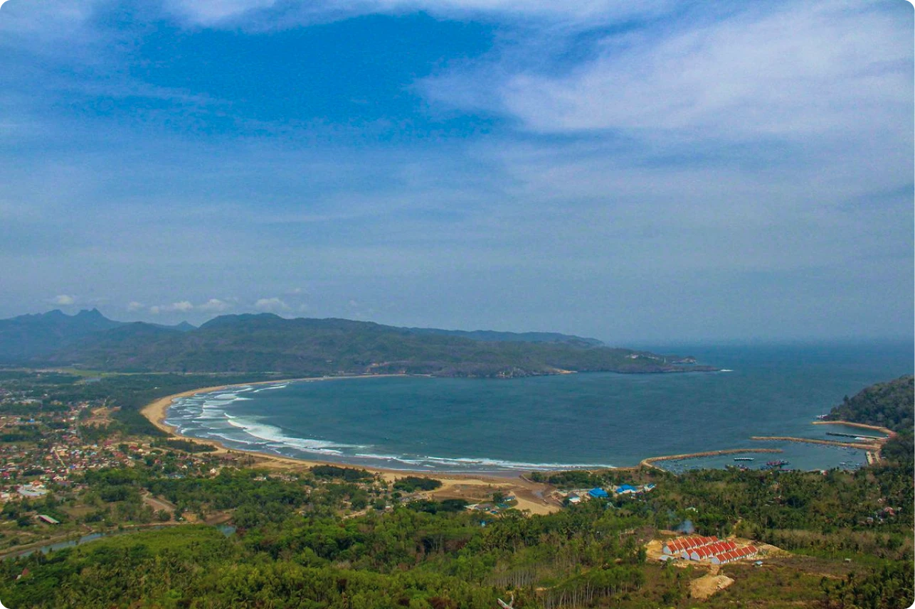
Pacitan Bay, East Java, Indonesia. Anggara Wikan Prasetya/Kompas.com
The bay’s alluring concave shape ironically amplifies the impact of tsunami waves, making it one of the most vulnerable areas. “Concave-shaped bays typically become centers of tsunami wave energy, resulting in significantly greater impacts. For comparison, Palu Bay, which experienced a massive tsunami in 2018, exhibited a similar pattern,” explained Jumadi, S.Si., M.Sc., Ph.D., a researcher from Universitas Muhammadiyah Surakarta (UMS), during an interview in his office on Tuesday morning (31/12/2024).
Another contributing factor is Pacitan Bay's proximity to the Java Trench, a highly seismically active subduction zone. Here, the Indo-Australian plate subducts beneath the Eurasian plate, creating immense pressure that could release a major earthquake at any time,

Jumadi, S.Si., M.Sc., Ph.D. Imam Safi’i/UMS PR
In his study titled “Multi-Scenarios Tsunami Hazard and Evacuation Routes Using Seismic Data in Pacitan Bay, Indonesia,” Jumadi utilized a numerical modeling approach to simulate tsunami wave propagation and flooding as well as network analysis using Geographic Information System (GIS) for evacuation modeling.
Jumadi explained that the chosen method effectively provides a clear picture of potential impacts and risks. “Our aim is to model tsunami scenarios using seismic data and assess evacuation routes to identify bottlenecks or potential congestion,” he stated.
Jumadi's research is based on seismic data collected from 1900 to 2023. Using this data, he developed three tsunami scenarios with different hypothetical earthquake epicenters.
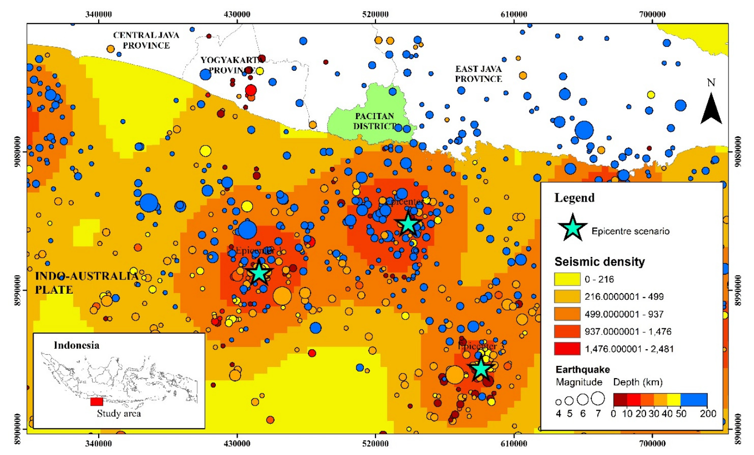
Seismic data for 1900-2023 in the study area to develop three tsunami scenarios processed by Jumadi from USGS earthquake data.
“I selected the earthquake epicenter based on seismic activity intensity. This approach differs from the megathrust theory, which typically focuses on seismic gaps, areas with infrequent earthquakes but significant potential,” explained Jumadi.
Tsunami simulations were conducted using Delft3D software, enabling wave propagation modeling from the earthquake epicenter to the bay. High-resolution bathymetry data from the Geospatial Information Agency (BIG) was also employed to accurately map the seabed morphology.
“This data integration produced flood maps that help identify the most vulnerable areas,” Jumadi elaborated.
The simulation results revealed differing impacts across scenarios. The first scenario, deemed the most severe, predicts a tsunami wave 6.28 meters high reaching the shore within 28 minutes. An area of 743 hectares is projected to be flooded, with Sidoharjo District experiencing the largest flooding, nearly 300 hectares.
The second and third scenarios indicate smaller waves, with heights of 3.5 meters and 3.6 meters, respectively, but still significantly affect hundreds of hectares. The second scenario has a travel time of 26 minutes and an flooded area of 390 hectares, while the third scenario takes longer, 35 minutes, with an impacted area of approximately 405 hectares
“In the model we used, factors such as slope gradient and land cover greatly influence how far the waves penetrate inland. Areas with forest cover are more capable of reducing wave impact compared to residential zones,” he added.
The research conducted by the UMS Geography lecturer also focused on identifying potential bottlenecks in evacuation routes. By utilizing GIS-based network analysis, Jumadi mapped evacuation routes from danger zones to three designated shelters established by the Pacitan Government.
The analysis results revealed potential congestion points at several key locations, such as Jenderal Gatot Subroto and Sinoboyo-Plumbungan road. “In the event of a tsunami, everyone will rush to the nearest shelter. Without proper route optimization, bottlenecks are inevitable,” Jumadi explained.
He also highlighted the unpredictable nature of human behavior in emergencies. “The assumption is that people will take the fastest route. However, in reality, some may detour to avoid traffic or choose paths they perceive as safer,” he noted.
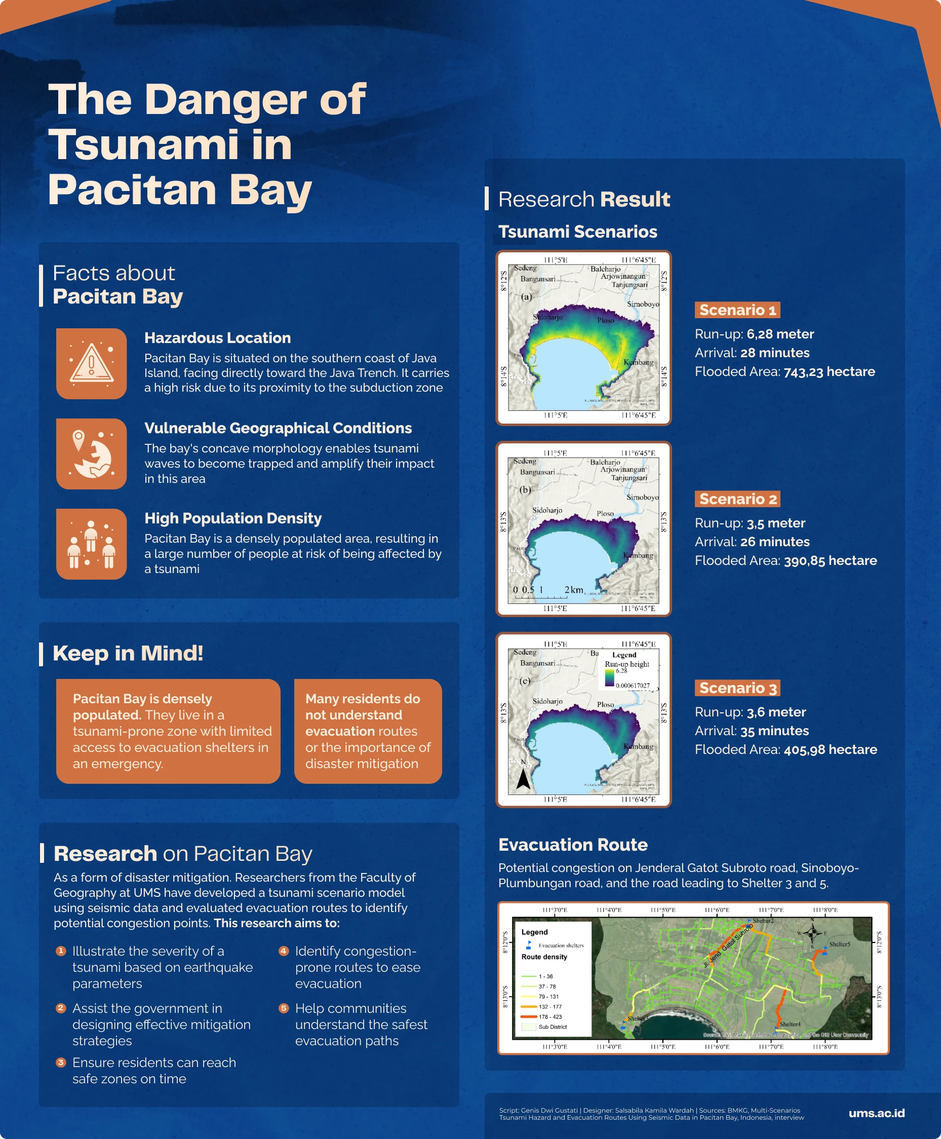
Jumadi's tsunami simulation involved 1,500 random points within the hazard zone, each representing an individual attempting to reach an shelter via the fastest route. The evacuation routes were then spatially combined with road network data to calculate route frequency and create a density map.
“Based on the data we have, main routes like Jenderal Gatot Subroto road definitely need special attention to ensure optimal use and prevent traffic congestion during evacuation,” added the lecturer for the Spatial Analysis and Modeling course.
Through these findings, Jumadi hopes to assist local governments in planning better evacuation routes. He further emphasized that the tsunami risk in Pacitan Bay is exacerbated by the community's limited understanding of disaster mitigation. Simulations for gathering point arrangements and optimizing evacuation routes have become urgent steps moving forward.
“With this research, we now know where potential bottlenecks occur. The next step is to optimize evacuation routes and add gathering points in strategic locations that are beyond the reach of tsunami waves. Then, conduct further simulations to determine the most optimal location settings and the number of points required. Our next research will focus on that,” he stated.
Despite the results, Jumadi’s research faced challenges, notably the limited availability of high-quality spatial data, which could impact the model’s accuracy. Moving forward, integrating real-time data, such as road conditions and population density, could improve the reliability of the simulations. Additionally, developing agent-based models to predict human behavior during emergencies is an essential agenda.
“Disasters are unavoidable, but good preparation can significantly minimize their impact,” he said. The generic model Jumadi has been developing for months is designed for application in other areas with similar disaster risks.
“We aim to create a model that can be used anywhere. Beyond these three scenarios, the model can test various other scenarios,” added the UMS disaster management expert.
Jumadi and his team continue to explore innovative ways to strengthen community resilience against disasters. After all, the risks at Pacitan Bay are just the tip of the iceberg when it comes to Indonesia's vulnerability to natural hazards
Writer: Genis Dwi Gustati
Translator: Farizal Luqman Majid
Editor: Al Habiib Josy Asheva
Bank Indonesia has held its benchmark rate at 5.75 percent, ending speculation of a hike to 6 percent that had circulated in recent weeks.
Nothing’s more special than reading curated news just for you.
Subscribe to the UMS Newsletter for free today.