Bank Indonesia Holds Interest Rate at 5.75%, What Is the Impact?
24 July 2026
Bank Indonesia has held its benchmark rate at 5.75 percent, ending speculation of a hike to 6 percent that had circulated in recent weeks.


The megathrust earthquake threat has become a significant topic of concern in Indonesia. Media coverage has heightened public awareness, focusing on the potential devastation such an earthquake could cause. This has led to growing anxiety about the possibility of a large-scale disaster. However, how accurate are these predictions?
Dr. Annisa Trisnia Sasmi, S.Si., M.T., a geophysics researcher at Universitas Muhammadiyah Surakarta (UMS), explained that megathrust earthquakes are not new to Indonesia. As the country lies within the Ring of Fire, Indonesia is highly vulnerable to seismic activity, including the threat of megathrust earthquakes

Map of the megathrust zones in Indonesia in 2017. Source: BMKG
In earth sciences, a megathrust refers to a fault zone that forms along tectonic plate boundaries. The converging movement of plates in subduction zones generates immense energy, leading to significant seismic activity in these areas. The term "mega" means large, while "thrust" refers to an upward movement or fault.
“Indonesia is geologically unique, as it lies between the Eurasian, Indo-Australian, and Pacific plates, forming a megathrust line that stretches from northwestern Sumatra, through southern Java, Bali, and parts of Nusa Tenggara. Megathrust also occurs in northern Papua and between the islands of Kalimantan and Sulawesi. So, it's not limited to the Sunda Strait or southern Java, as widely reported,” explained Annisa, a geography lecturer at UMS.
She explained that Indonesia sits at the meeting point of several complex tectonic plates: the Indo-Australian plate to the south, the Eurasian plate to the north, and the Pacific plate to the east. This convergence of tectonic plates makes the country highly susceptible to earthquakes, tsunamis, and volcanic eruptions.
Indonesia can be compared to a puzzle, positioned between three large pieces of tectonic plates. The megathrust represents the boundary where these pieces meet. Like the edges of puzzle pieces, the boundaries have hollows or gaps, which can be likened to megathrust trench.
Annisa emphasized that the immense force generated by a megathrust earthquake can severely damage the surface and trigger a tsunami. When such an earthquake occurs, the powerful thrust on the seafloor causes large vertical shifts, displacing a significant volume of water. This displacement can result in a tsunami, much like the one caused by the 2004 Aceh earthquake.
“The recent buzz in the news is centered around the megathrust threat in the Sunda Strait and southern Java. Indeed, research evaluating and investigating the potential for megathrust in this region has intensified, particularly as we consider the seismic gap zones in southern Java,” explained the lecturer who teaches the Tropical Disaster Management course.
Read more: Unraveling the Seismic Puzzle on the Northern Coast of Lombok Island
Annisa explained that seismic gap zones are regions with a high potential for seismic activity but have not experienced significant earthquakes in the past 50 to 100 years. These zones can be found along various areas of the Sumatra-Andaman megathrust line, extending to southern Java.

Three “seismic gap” zones without significant activity in the southern shore of Java-Bali. Source: National Research and Innovation Agency
Some sources have identified seismic gaps in the Bali Strait and around Alor Beach. These areas need close monitoring due to the potential for significant earthquakes and tsunamis, which could have devastating effects on the region.
Will a megathrust earthquake occur in Indonesia?
According to BMKG, Indonesia is surrounded by at least 16 megathrust zones. These zones are spread across six active subduction areas: the Sunda Subduction, Banda Subduction, Maluku Sea Plate Subduction, Sulawesi Subduction, Philippine Sea Plate Subduction, and North Papua Subduction.
Below are the megathrust zones in Indonesia and their maximum potential earthquake magnitudes, as outlined in the 2017 Map of Earthquake Sources and Hazards by the National Center for Earthquake Studies. This map is currently being updated, with the revised version expected to be completed by the end of 2024:
“The viral news about the potential megathrust earthquake is an opportunity for academics to educate the Indonesian people about the dangers of geological disasters in their region. It should not be interpreted as something intended to scare the public,” Annisa warned.
The threat of a megathrust earthquake is not just a rumor and we should take it seriously. However, it's important to respond to such information wisely and avoid assuming the disaster will happen in the immediate future.

According to Daryono, Head of the BMKG Earthquake and Tsunami Center, while Indonesia does have the potential to experience a megathrust earthquake, experts cannot accurately predict when such a disaster might occur. This is due to insufficiently advanced technologies and data.
He added, “it’s crucial to have a thorough understanding and high level of preparedness to reduce the risk of megathrust disasters. This way, we can be better equipped to handle the worst-case scenarios.”
Collaborative efforts between the government, academics, and the community are essential in addressing the threat of megathrust earthquakes. As Annisa pointed out, disaster mitigation isn’t solely the government’s responsibility; it is a shared duty for all of us as citizens who care about the safety of ourselves and others.
First, as the responsible authority, the government must implement policies prioritizing public safety. This includes ensuring that spatial planning and infrastructure development regulations are aligned with disaster safety standards.
Second, the government should develop and maintain an early warning system for tsunamis integrated with real-time seismic data. This requires installing earthquake detection devices on the seabed and establishing a rapid communication system to ensure timely alerts.
According to Detik.com, the BMKG is currently working to mitigate or reduce disaster risks in areas with the potential to experience a megathrust earthquake.
Dwikorita Karnawati, head of the BMKG, explained that the agency has installed 39 seismographs (earthquake recording devices), 20 accelerographs (which monitor ground acceleration over time), and 22 automatic water level monitoring devices in the Banten and Sunda Strait regions. These efforts aim to enhance earthquake and tsunami monitoring in these high-risk areas.
Third, disaster mitigation should include education and training. The government and academics must work hand in handto raise public awareness through intensive outreach programs, educating people about the dangers of megathrust earthquakes and teaching them how to protect themselves in the event of a disaster.
"Regular emergency evacuation training is essential in schools, offices, villages, and across all levels of society. This training helps ensure that people know how to respond in disaster situations. It's important to teach individuals how to stay calm, identify safe evacuation routes, and understand the appropriate actions to take during an emergency," Annisa emphasized.
She believed Indonesia can learn from Japan, another archipelago with similar risks of geological and hydrometeorological disasters. In Japan, infrastructure, education, and technology are all designed with safety in mind, aiming to reduce the risks posed by frequent natural disasters.
It is also important for us to learn about safe evacuation methods, especially when we are inside a building. Avoid glass and furniture that can easily collapse when trying to escape. Take the stairs instead of the elevator. Gather at the designated gathering point, and wait for further instructions and news from the authorities.
“If you are near the beach, immediately move away from the shoreline and head to higher ground, such as tsunami shelters or hill areas," he added.
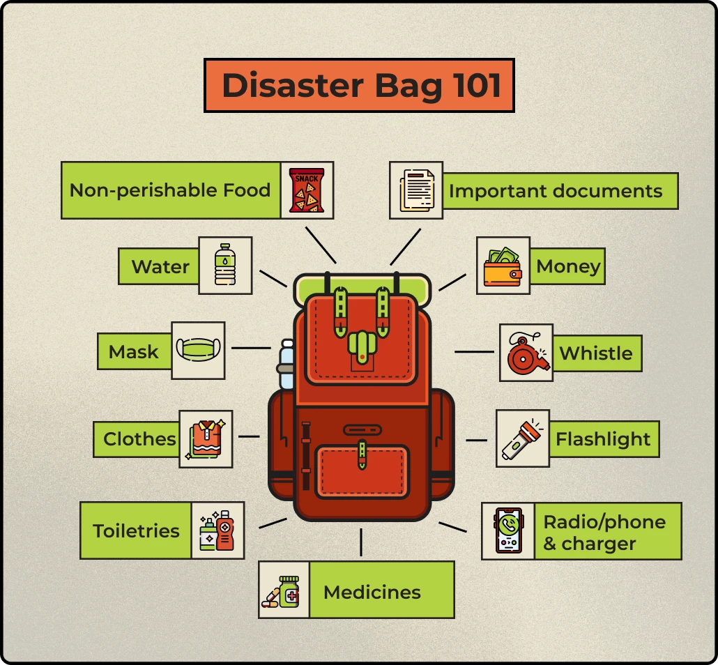
Illustration of a disaster preparedness bag. Source: Kompas.id and the Meteorology, Climatology and Geophysics Agency
In addition, people should also prepare disaster preparedness bags, special bags packed with essential equipment and valuables, ready to grab in case of an unexpected disaster.
“Don’t let anxiety and fear hold you back! With the right disaster preparedness and a solid understanding, we can work together to reduce risks and improve our readiness,” she concluded.
Writer: Genis Dwi Gustati
Editor: Al Habiib Josy Asheva
Translator: Farizal Luqman Majid
Bank Indonesia has held its benchmark rate at 5.75 percent, ending speculation of a hike to 6 percent that had circulated in recent weeks.
Nothing’s more special than reading curated news just for you.
Subscribe to the UMS Newsletter for free today.